Today was special for me. I took a long solo hike
across diverse terrain that combined new trails and discoveries with a return
to some familiar favorites. Most of the day would be spent in Reef Bay, an area
I have hiked several times before. It’s a very large bay with several different
beaches and many interesting ruins.
Most people take the main trail down from Centerline
Road, which runs along the high spine of St. John. From there they can hike all
the way down to the old sugar mill near the beach. It’s one of the most popular
NPS trails on the island. Very well maintained and has NPS plaques for various
things along the way. I almost always see groups and families hiking this trail
and it is a great one for that kind of thing.
 |
| Reef Bay in the distance as seen from the trailhead of L’Esparance Road |
I will end up at that beach today but I will be coming
down the old L’Esperance Road, a more difficult, remote and rarely used trail
to get there. I expect to see several interesting things. There are extensive
ruins along the way. The landscape will gradually shift from tropical forest to
desert – I am heading west to east and the east end of the island is by far the
driest. But this particular “gut” I am starting out in is one of the wettest.
Fresh water and the large protected bay are the key reasons the ruins exist;
why settlers built extensively here. I may see fresh water. I should see a nice
variety of plants and animals. And I should have the trail pretty much to
myself… assuming I don’t run into The Trail Bandit again!
My plan is to hike and explore ruins and get to that
beach before the heat of the day. There I can swim, eat, and rest in the shade.
Then I will continue to hike east picking up the trail to Lameshur Bay. If
everything works out, my family will be playing on that wonderful, remote beach
and I will meet them late afternoon.
By 9:30 it
is already a bit hot and sticky as I get to the trailhead, check my gear and
then begin my descent. As expected I am quickly engulfed by tropical forest.
The old road was well built and is still in good shape in some spots with
retaining walls clearly visible (left side of frame):

Other areas are overgrown, tumble down:

Look closely at these wild pineapple (above) that are
encroaching on the path. There’s a bunch of leaves that look like they were
just recently hacked off to clear the path so people could pass. I happen to
know there have been sightings of The Trail Bandit along this very path in recent
days…hmm… wonder if there is any connection?!??!
After hiking steeply downwards for about 20 minutes
the trail takes a sharp hairpin turn and I see the remains of an old stone
bridge that crosses the gut and leads to some ruins. This is one of the few and
by far the best examples of this kind of bridge I have seen on St. John


I cross the bridge and approach the ruins with
increasing excitement. I’ve seen a lot of ruins on this island. These are
extensive, diverse and with a lot of walls still standing.


I ascend thru three levels of structures being careful to stay clear of things that can bonk you on the head or break your ankle or give way and let you fall down a steep slope and kill yourself. That’s the thing about these old stone structures. They will stand for centuries - until one day they don’t. Wandering towards the back of the property I find a lone above-ground grave.

 |
Louise Sommer died and was buried here 99 years before I was born.
I wonder what her life was like?
|
I sit down among the ruins for a while to rest, think and have a drink of water. But I need to keep moving. There is a long way to go and if I am going to time the mid-day heat right I can’t sit here on my butt all morning daydreaming about what life was like in the 1700’s.
I re-cross the old stone bridge and continue to
descend as the road follows the gut closely. Not much further along I hear
what sounds like running water and soon I encounter a small
stream running down the middle of the gut. It’s moving right
along and there are several decent size pools of water downstream.
 |
| Fresh Water Stream on St. John |
As you might expect in a tropical forest there is
wildlife. Giant millipedes, deer tracks, Hermit and Land crabs, birds,
insects, gigantic termite nests and the biggest butterfly I have ever seen.
 |
| Typical Termite Nest. Many of these on the island. |
 |
Also found this guy (a box turtle ?) - not something I have seen here before.
|
I continue to descend. The trail is starting
to flatten out now and the landscape is becoming drier. Cacti begin to
appear. A few at first, off to the sides of the path. Then more and bigger
ones, some of them crowd the trail and I must exercise a bit of caution to
avoid spines:

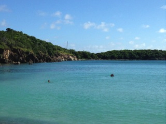
I am getting really hot and tired. I have been hiking for almost 3 hours now and need a break. Quite suddenly I hear waves and they quickly grow into the roar I recognize as the sound of the broad breakers of Reef Bay. I know I am getting close to the beach. The L’Esperance trail dead-ends into a Reef Bay beach trail. Normally I go to the beach to the left as I would have come down the trail from that direction. Today on a whim I decide to go right and am quickly rewarded with a lovely sand beach that is new to me. Long, wide with easy safe entry into the water. There is one family there and they are packing up to leave. Soon I will have the whole thing to myself:
I am getting really hot and tired. I have been hiking for almost 3 hours now and need a break. Quite suddenly I hear waves and they quickly grow into the roar I recognize as the sound of the broad breakers of Reef Bay. I know I am getting close to the beach. The L’Esperance trail dead-ends into a Reef Bay beach trail. Normally I go to the beach to the left as I would have come down the trail from that direction. Today on a whim I decide to go right and am quickly rewarded with a lovely sand beach that is new to me. Long, wide with easy safe entry into the water. There is one family there and they are packing up to leave. Soon I will have the whole thing to myself:
 |
| Reef Bay looking West |
 |
Looking East. Boy am I ready to strip off these sweaty clothes and swim!
|
I set up my little base camp to refresh for the second half of the hike. ( Are those his pants on that log? I hope he waited until that family left ;)
 |
The Base Camp
|
The worst heat of the day passes (mostly!). It’s time
to get moving again although I could easily spend the rest of the day right
here.
I retrace my steps and quickly pick up the old
familiar Reef Bay sugar mill trail. I’ve hiked this part a couple of times and
know it well. I start to see a few more people - remember this is the
other trail that is great for families, etc...
 |
| Reef Bay Sugar Mill |
I don’t linger here very long as I need to get up and
over the next ridge to Lameshur bay. I know that trail too. It is going to be pretty
hard. It’s a quick steep climb with some rugged terrain and very hot and dry.
My timing is not great - it’s about 2 PM now
- but there’s nothing to be done about that except go slow and take frequent
water breaks.
Just like I remember, the hot dusty trail
ascends quickly and has some great views.
 |
Looking back towards Reef Bay and the beach where I went swimming and had lunch.
|
The trail finally crests the ridge and begins to
descend again and a good thing too because it’s really hot now. I have gone
thru more water than I planned for this part of the hike. I have plenty of
reserve but I am surprised at how much I have consumed. I’m getting tired. I
know this is when people make dumb mistakes and get hurt so I take
frequent breaks and try to go slower.
I pass some familiar landmarks from previous hikes and
know I am near the destination and can make it. I round a corner and catch the
first spectacular view of the two Lameshur bays.
 |
| Little Lameshur Bay (Foreground) and Great Lamshur (Distance). |
It’s too beautiful to pass so I sit down for a
few moments. I really love this part of the island. I have spent a LOT of time
exploring these bays and the trails around here. I have a picture of Harrison
(now 23) at age 1 year eating a giant handful of sand off that beach. My
friends who live on St. John have their home nearby. I could sit and stare at
this for a long time but the bugs have other ideas. They descend in a swarm.
The message is clear - time to move on or be eaten alive.
Twenty minutes later I walk onto the beach. I see my
kids out in the water splashing and having fun. “It’s Dad”, they
shout. “You made it!”.
Yes I did.
No comments:
Post a Comment